
Projects
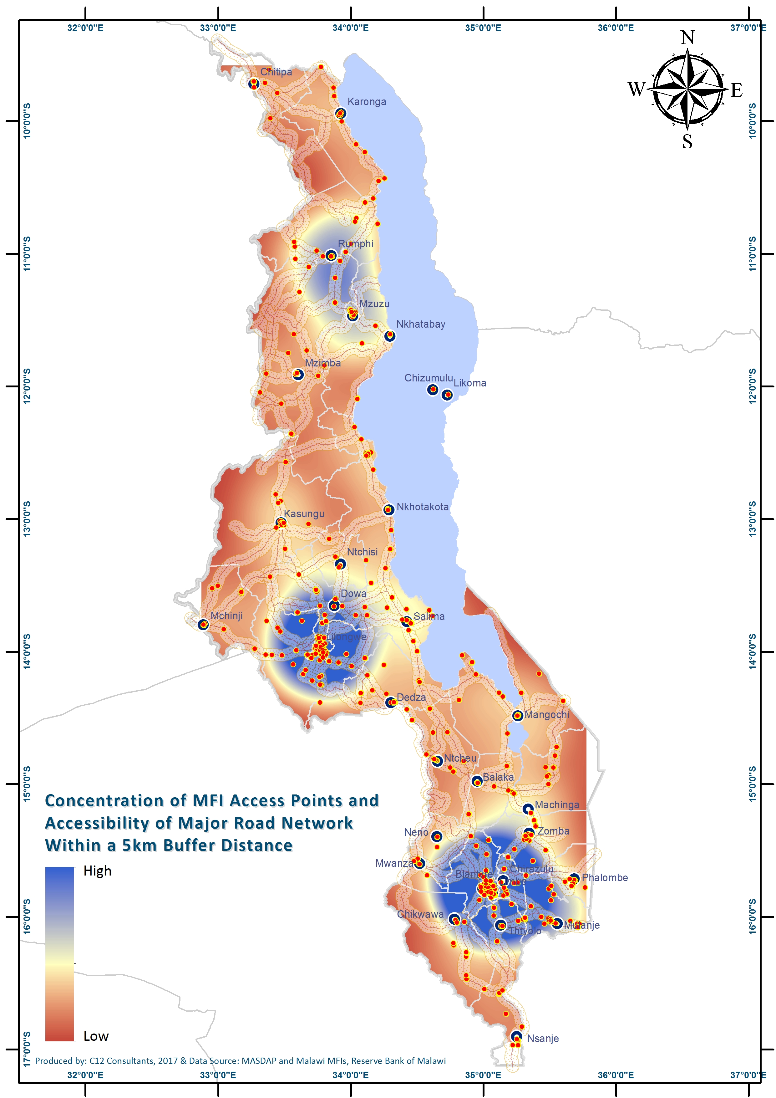
GIS Mapping: National-wide Footprint of the Micro-finance Sector - Deutsche Gesellschaft für Internationale Zusammenarbeit (GIZ) (2017)
C12 conducted a national scale exercise mapping all micro-finance institutions and products on offer in Malawi.

Technical assistance: GIS Monitoring and evaluation support & Training - TROCAIRE (2016)
C12 developed and trained staff on a GIS database for active M&E use.

hazard and vulnerability mapping and development of an early warning system toolkit for Mangochi district; cooperazione internazionale - coopi (2017)
C12 is currently implementing a project using GIS data including drone imagery to generate hazard and vulnerability maps for the Mangochi district, and update the existing map for Salima District. The project also features an EWS component for project implementers and district officials.

STRATEGIC PLANNING - POVERTY AND VULNERABILITY ANALYSIS - SELF HELP AFRICA (2016)
C12 completed a GIS analysis of district level development indicators relevant to SHA’s strategic direction. The output will aid in identifying SHA’s future target areas.
Strategic Planning - integrated contextual analysis - concern worldwide (2016)
C12 produced an analysis of national development indicators, district level actors, structures and development issues in a detailed contextual analysis. This report will be utilized by Concern for strategic programming purposes.

GIS Mapping - Agriculture Supply Chain Analysis (2014)
C12 produced a detailed geographic analysis of the small holder agricultural sector in eastern Zambia. The work incorporated cooperatives, sheds, trading centres, transport lines, and agricultural production of 7 different crops aimed at identifying key areas for investment. The work was completed as part of the Profit+ project with Imani Development.
GIS Mapping: Agricultural Production and Yields of Rice and Pigeon Peas in Malawi (2014)
C12 produced detailed choropleth maps of rice and pigeon pea production in Malawi. The work was done for Imani Development under the Business Innovation Facility (BIF), funded by DFID. Click here to view maps.
GIS Mapping & Coffee Manual Climate Change Chapter (2014)
C12 was contracted by Imani Development to produce a full GIS assessment of ideal coffee growing conditions in Malawi. The assignment was for submission to the Coffee Association of Malawi (CAMAL) as part of the Trading for Climate Smart Supply (TraCCS) project funded by the Scottish Government. A chapter on climate change vulnerability was also produced as part of a revision of the Coffee Growing Manual of Malawi. Click here to view maps.